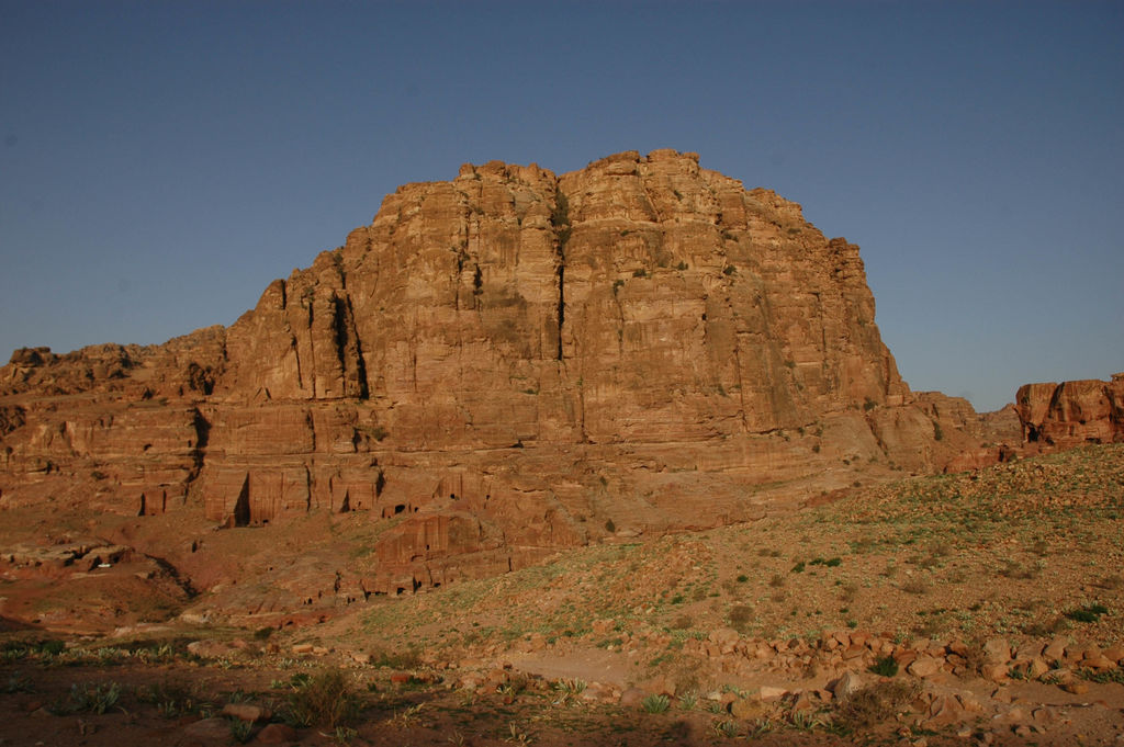
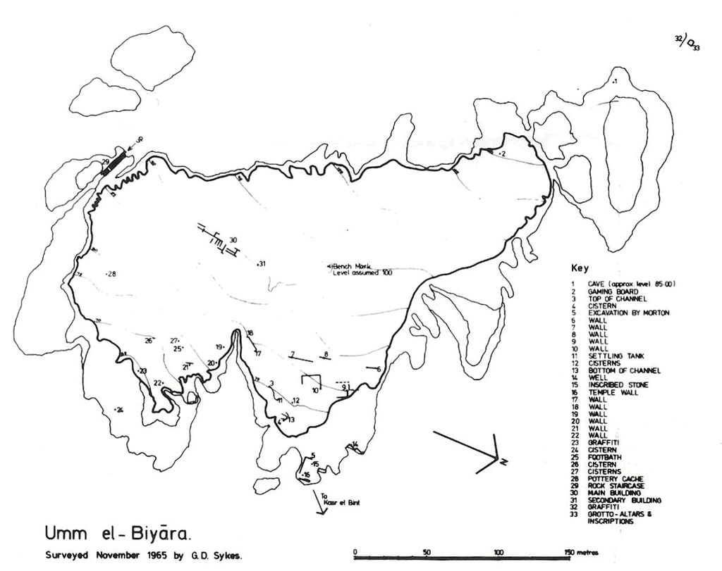
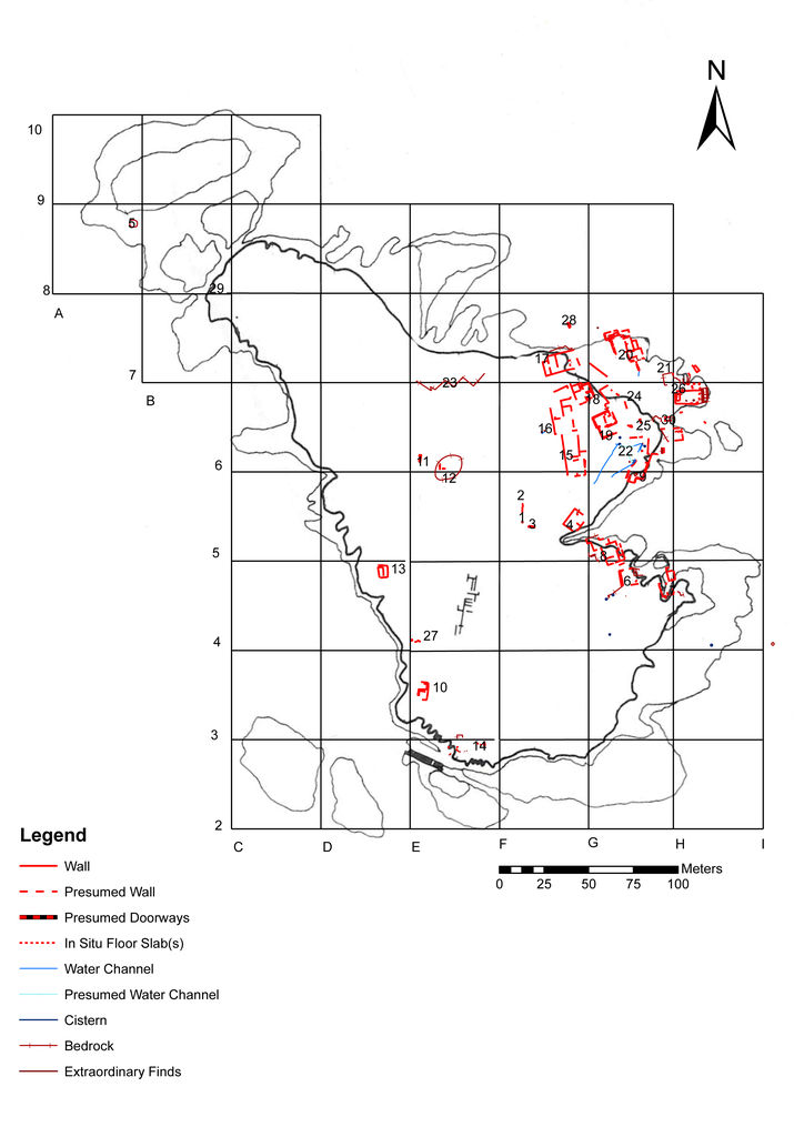
Outline of the International Umm al-Biyara Project

Umm al-Biyara, the huge rock massif dominating the centre of Petra (fig. 1), can be considered the most important elevation connected to the city of Petra, irrespective of whether it is to be identified with biblical Sela or with „the rock“ referred to by Diodorus Siculus for the events of 312/11 BC Diod., Geogr. 19, 94, 1–100, 3; for the text and a commentary see Hackl, Jenni and Schneider 2003: 439–453. . Previous archaeological work at Umm al Biyara was undertaken in the 1950s and 1960s, preceded by some observations already in the 1930s. Most of these activities were focussed on Edomite structures. In general terms, Nabataean structures on top of Umm al-Biyara received little attention before the mid-twentieth century. For example, Brünnow and von Domaszewski only consider rock-cut structures on the east flank of Umm al-Biyara Brünnow and von Domaszewski 1904: 295 nos. 355–357 [misleadingly named el Habis]. . The same is true for G. Dalman who treats three sanctuaries below Umm al-Biyara in a more detailed way, but, as is clearly indicated by the subtitle of the chapter and by the descriptions, these are structures on the terraces beneath the plateau and not on top of it Dalman 1907: 226–9; these structures on the so-called northern terrace have been dealt with in detail by Lindner 1997: 293–303. . It was with Nelson Glueck’s visits to the site in the 1930s that the plateau of Umm al-Biyara became more intensively dealt with, although not so much for the Nabataean remains but rather for the Iron Age pottery that was collected there Glueck 1934–35: 82. . From that moment on, the question of whether Umm al-Biyara was the rock of Edom became a major issue mostly for Iron Age archaeologists For detailed information see Bienkowski in press. .

Fig. 1: Umm al-Biyara from W (photo: S. G. Schmid)

In 1955, an expedition organised by the American Schools of Oriental Research at Jerusalem conducted, among other activities, a detailed survey and a few soundings on top of Umm al-Biyara Morton 1956. . William Morton was able to make some valuable observations regarding Nabataean structures on the site. For example, he observed that Nabataean pottery was mainly to be found on the north-eastern sector of the plateau and he already concluded that this is the area commanding the best view of the city enclosure below and in which are concentrated practically all of the foundation lines of Nabataean buildings Morton 1956: 29. . Morton counted about 13 different buildings on several terraces in that specific area, that he considered being of Nabataean date ibid. . His attention was particularly caught by a huge rectangular structure on the very edge of the north-eastern promontory of the plateau (cf. fig. 2) Morton 1956: 30–31. . He described three steps at the end of that building, obviously leading into nowhere right across the cliff (cf. ST 26 on fig. 3), and proposed that the structure initially extended further in that direction, using foundational walls that had broken away in the meantime. A substantial block with architectural decoration led to the presumption of a richly decorated building going far beyond a temporary refuge for the aged and for women and children as reported in the account of Diodorus Morton 1956: 31. . Finally, Morton suggested a date within the first century CE and a function as an officially staffed stronghold and observation post, perhaps with provision for ritual observance ibid. .

Fig. 2: Schematic plan of Umm al-Biyara, drawn by the expedition of the American Schools of Oriental Research at Jerusalem (1955)

From 1960 to 1965, Crystal-M. Bennett spent considerable time and energy in exploring the peak of Umm al-Biyara The final publication of these excavations has been prepared by Piotr Bienkowski: Bienkowski in press; on the life and career of Bennett see now Prag 2010. . Although the Iron Age settlement was clearly her focus, on several occasions Nabataean remains are dealt with in preliminary reports. For instance, in an article in 1966, the huge structure described by Morton is illustrated and referred to as a building that may have been a small temple, but has been amputated from its fore part by a earthquake or some other catastrophe Bennett 1966: […], y compris un bâtiment qui peut avoir été un petit temple, mais qui a été amputé de son avant-corps par un tremblement de terre ou quelque autre catastrophe; in the caption to her fig. 4, a picture of the rock-cut steps leading nowhere as described by Morton, the structure is called a Nabataean temple. . In 1980 Bennett published a short report on Nabataean Umm al-Biyara, where the structures observed by Morton are published as ground plans (see here fig. 2) and interpreted as connected with the Qasr al-Bint and, therefore, ascribing the building a religious function Bennett 1980: 211: Its dominating position, overlooking the main street of Petra and the Temenos of the Temple of the so-called Qasr el Bint, suggest that it might have had some connection with the latter, which was the major Graeco-Nabataean temple in Petra; in the caption to Bennett 1980: fig. 3, the building is called a possible important Nabataean temple. Strangely, there is no mention of Morton’s article although his trench is even indicated on the respective plan. .

More recently, scholars have mostly abstained from a too precise interpretation of the Nabataean structures on the north-eastern edge of Umm al-Biyara. For example, Ian Browning remains cautious as to any identification of the aforementioned Nabataean ruins Browning 1989: 185: It has been suggested that this was the site of a temple (…). Until the site has been excavated it would be vain to speculate on why these steps were so perilously sited. . Manfred Lindner, one of the most intimate connoisseurs of the topography of Petra, had in mind a temple or a palace when looking at the Nabataean structures on top of Umm al-Biyara Lindner 1997: 44. .

Fig. 3: Schematic plan of structures on Umm el-Biyara, drawn by the International Umm al-Biyara Project (2010)

As a matter of fact, the only element that was mentioned in favour of the interpretation as a Nabataean temple was its presumed orientation towards the city’s main sanctuary of Qasr el-Bint. Upon verification it turned out, however, that the Qasr el-Bint is not at all visible from the spot of the presumed temple, since the hill of el-Habis obstructs the view For some preliminary arguments dealing with the issue cf. Schmid 2009, and in press. . During the past five years, it became clear that both co-directors of the International Umm al-Biyara Project (IUBP), i. e. Piotr Bienkowski (Manchester) and Stephan G. Schmid (Berlin) had similar questions and interests regarding Umm al-Biyara and, as a result, the present project was born, aiming at a better overall understanding of the plateau of Umm al-Biyara, mainly regarding the Nabataean period.

For the time being, two main objectives for that project can be formulated:

  • finding out more about the exact plan, date and function of the Nabataean structure(s) observed by previous research and mostly concentrating on the north-eastern edge of the plateau
  • verifying whether there is continuity or not between the Iron Age occupation and the known Nabataean structures that seem to date no earlier then the later first century BC (see below).

For that purpose, in 2010 a first season of roughly three weeks was devoted to a survey of the summit of the mountain (see IUBP 2010), regular excavation is planned to start in 2011.